 Aerial
View Aerial
View
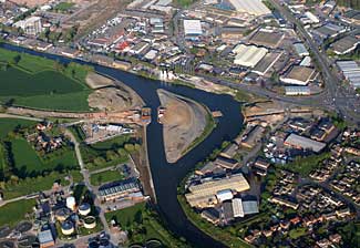
This aerial view shows
the new channel cutting off the old bend and the canal continuing
to the upper left towards Gloucester. It also shows the line of
Gloucester's South West Bypass which will cross the new channel
and the filled-in old channel to meet Cole Avenue on the right edge
of the picture. (Photo: © Robert Bewley 5 May 2006)
|
 Tall
Ship Uses New Cut Tall
Ship Uses New Cut
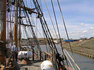
The Earl
of Pembroke, that has featured in many films, was the first
tall ship to pass through the new cut when she left Gloucester on
7 May. This was also a first for her pilot who had used the old
bend when taking her up to Gloucester for overhaul. (Photo: Brian
Furniss)
|
 Public Viewing Gallery Public Viewing Gallery
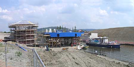
The
County Council provided a public viewing gallery overlooking the
site of the bridge being built to carry Gloucester's South West
Bypass over Two Mile Cut. The picture taken from the gallery on
8 June shows passenger boat Queen Boadicea II passing the
blue sections of the the bridge deck that are currently being supported
on a steel frame while being welded together. On the left, the structure
of the bridge control cabin is taking shape. The public viewing
gallery has been closed.
|
Further Information
For
project plans, earlier & later progress and historical background,
see links above. |